A new employee showed up at a place I once worked and a veteran employee quickly came to the conclusion that she did not like the new employee. She began a whispering campaign about the new hire, attributing certain negative job-related qualities to him, and before you knew it, other people were repeating those aspersions when the new hire’s name came up—even though they had never actually seen any of those things themselves. The new employee was suddenly the victim of widespread preconceived notions, without even knowing what was going on, much less having an opportunity to do anything about it. He struggled his entire time at his job under the burden of those undeserved, preconceived notions. What struck me about this incident was how quickly others accepted the aspersions against him, with no proof or evidence at all. They were simply sheep following the lead of someone more dominant. It was a depressing but useful life lesson.
[Remember that you can click on each image below to see a larger, better image. Also, the EXIF data for each image contains GPS coordinates that you can use to locate the exact place where the photograph was taken. Copyright information: All of the text and images on this blog are the intellectual property of Mark Pitcavage. Attributed, non-commercial (ONLY) usage is permitted under the Creative Commons License.]
in my “day job” as an expert on extremists, I have discovered that extremists both left and right tend to think of the majority of people as sheep, blindly accepting what the governments, the international corporations, the Freemasons, the Jews, the New World Order or whatever other perceived enemy of theirs they thought was deluding the people. Right-wing extremists even coined a word for this, referring to the American people as the “American sheeple.”
Needless to say, it’s a cynical worldview to have. Of course, extremists evolve this attitude because the vast majority of people don’t agree with them (if their views were popular, they wouldn’t be considered extremists). Faced with this obvious fact, extremists typically do not question their own views but rather assume that the non-extremists are simply to blind to see the truth, because they’ve been lulled to sleep by [insert favorite conspiracy/enemy here]. It’s a psychological rationalization as to why their own views are unpopular.
If you start feeling too cynical about your fellow human beings, my prescription is to head out into the countryside. It works wonders. At least it does for me. If it doesn’t for you, that’s probably because you are one of the sheeple.
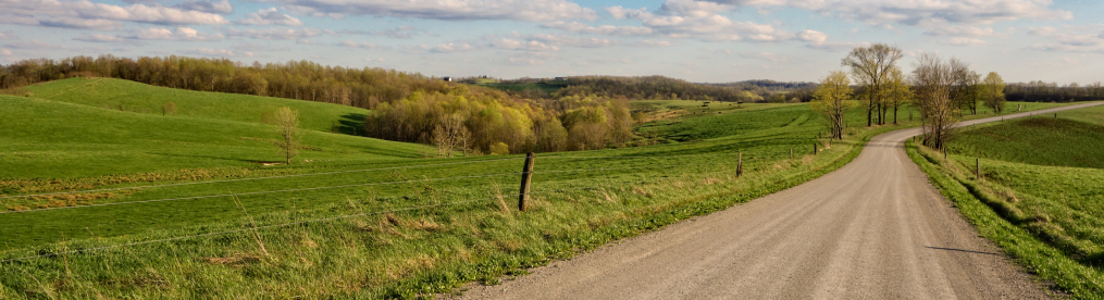
On this particular day, a frigid but sunny winter day in February 2016, I decided to head out and see what I could see. I chose a favorite direction, southeast, heading east on the highway to Zanesville, then southeast from there until I entered the comforting embrace of Ohio Appalachia.

I think this photo of a lone cow out for an early morning graze sets the scene nicely. A pasture, a wooded hill in the background, yup, we’re getting into Appalachia. This photograph was actually taken east of Zanesville only a little south of I-70. If you look closely at the expanded version of the photo, you can see the cow’s breath. It was quite brisk this day.

In Salt Creek Township, near the interestingly named White Eyes Creek, I came across these abandoned mobile homes—there are four in all, though they are not all visible here. I believe they were not just dumped here but were probably lived in here at some time—satellite imagery shows a dirt driveway curving around in front of them. However, there is a house not far to the right of the photograph that seems to share the property. So I am not quite sure what to make of it.

A number of hills in Ohio sport cemeteries. This has interested me, because it would seem at first glance that many hills might not be very easy places for cemeteries (on the assumption that they would be rockier). On the other hand, I suppose, hills were not suitable for many other endeavors, such as farming, and were thus more available for other purposes. This particular photograph is part of a fairly large cemetery outside the hamlet of Chandlersville. In fact, I believe it is called Chandlersville Cemetery. The larger part of it on flatter land and this smaller portion across the street on a slope.

I headed south, skirting the Blue Rock Forest, which allowed me to spot this hilltop farmhouse. I am not sure if is abandoned. I decided to check satellite imagery, to see if I could spot vehicles or other signs of current habitation, but didn’t see anything. But my attempt to find out more led me down into one of those odd, but oddly enjoyable, little rabbit holes that appear from time to time when I write these blog entries.
So when looked at the satellite imagery (see below; the orange square marked ‘5’ is from where I shot 5 photos of the house; the empty orange square is a GPS ghost), I noticed that Google Maps was naming something nearby with the enchanting name of Harmony Hollow. This struck me as rather odd, because there was no community or other notable feature there, like a park or cemetery. What was this Harmony Hollow?

Naturally, I began to do Google searches related to Harmony Hollow. What I discovered was that it was simply a terrain feature, just a hollow, in fact. Hollows (or Hollers) are small valleys that may or may not have a stream in them. Harmony Hollow was simply one of many hollows in the area, but one which had been named by somebody, and as a result, it was so named on early topographical maps of Ohio.
I soon came across an on-line version of one of these topographical maps, and you can more clearly see Harmony Hollow indicated here as the valley that it is—complete with a tiny stream (which does indeed show up on Google Maps if you look closely enough for it).

However, this topographical map presented questions of its own, because look what is to the northwest of Harmony Hollow on the map—some sort of place name called McDonald. Judging by the topographical map, McDonald appears to be a collection of several structures at the crossroads where Sugargrove Road (the road I was on) intersected with McDonald Road (which I had just passed). Today, there is a home and, across the street, an abandoned home. That is all that is left of “McDonald.” The house I had photographed was basically located between McDonald and Harmony Hollow.
So McDonald was once a place in Ohio but not it is not. This called for more research—and it was not easy, as you might suspect, given that McDonald is a more common name than, say Arglebargle. I am sure that Arglebargle, Ohio, would be easier to research. Nevertheless, I eventually found the history, or at least some of the history, behind McDonald, Ohio. In 1806, a Scotch-Irish immigrant named James McDonald crossed the Atlantic and, after a sojourn in Pennsylvania, eventually wound up in Muskingum County, Ohio, by 1816, where he became a farmer. His son, John McDonald, married a Virginia girl, Sarah Mershon, and together they had four children, two of whom lived to full adulthood. Emeziah McDonald was one of the two, the third overall, born in 1846.
Emeziah McDonald became a schoolteacher but after several years of this, he got tired of the little runts and turned to business pursuits, opening up a country store in Salt Creek township, which did very well for itself, carrying a “large and carefully selected line of goods.” Emeziah also established a post office and became postmaster, thus giving his property a place name for people to send mail: McDonald, Ohio. E. McDonald married Martha Cline and had “four interesting children.” For good measure, he was a justice of the peace for 27 consecutive years. He was also a Presbyterian, a Republican, and a member of the Independent Order of Odd Fellows, a fraternal organization. He is…the most interesting man in the world.
Emeziah died a century ago and there’s no telling how long ago his store and post office disappeared but the name lingers on, just barely, in this little spot where he lived.

As the earlier topographical map indicates, a bit down the road from Harmony Hollow is/was something called Sugar Grove Chapel. I can find no hint of a chapel either in my photographs or via satellite view, but there are two small cemeteries quite close to each other, and it is possible that a chapel may once have stood between them. This is a photograph of one of them. Note that it is not abandoned; someone, at least, keeps the grass mown. Pictured here are three gravestones (ignore the distant one on the far let). The one on the left belongs to John Crumbaker (1857-1922) and his wife, Margaret (1858-1937). I can’t make out the one in the middle. The one on the right is dedicated to Joseph Osborn (1821-1897). His wife, Sylvenia, is also buried there or nearby. A little research reveals that Margaret Crumbaker is the daughter of Joseph Osborn.

Down Sugargrove Road a bit further, I came across this small cabin—still occupied, it seems, with actual living human beings—unlike the McDonalds, Osborns and Crumbakers of yore.
I eventually turned off Sugargrove Road onto a different road that went over a little hill and when I crested the hill and looked down onto the countryside below, I found a rather unusual site.

My road was blocked by a flock of sheep! Some enterprising sheep, it seems, had found a way through the fence and was attracted by the virgin grass on the other side of the road. Sheep being sheep (and now you know why I began this blog the way I did), the whole herd quickly followed, not even knowing why, and soon a sheepload of critters were feasting right in front of me.
This put me in a bit of a quandary, as I did not want to turn around, but obviously had no desire to hurt any sheep. Luckily, that was not a problem. Somehow—I am not sure how—the owners of the sheep noticed what was going on very quickly. Indeed, if you look at the center background of the above photo, you will see a truck pulling onto the road. It contained a farmer and his son who drove up to the herd and began to shephard them (literally!) back into their enclosure.
The whole little escapade, an entirely unexpected example of great timing, with them getting out right at the moment I came into view, was one of those little pleasures you get from these excursions away from the madding crowd. Just a couple of months earlier my path was blocked by a downed glider—now it was sheep! If you can’t appreciate this, go back to your casino, Mr. Trump.

As can be seen from the above photograph, I was now in a slightly more open patch of land, with less woods and more farmland, though the terrain was still fairly hilly. A bit south of the sheep I came across a small hilltop church, the Blue Rock Baptist Church. The church itself dates well back into the 1800s, though this building may be newer.

About a thousand feet to the east of the church I began to go up a little rise and took a photo of the house below me., still in the shadow of the wooded hill next to it (to the right, off camera). My one memory in taking this photograph was how cold it was; the earth seemed rock hard.

I continued driving on, back into a smallish patch wooded hill country, where I saw this tiny but interesting cottage. I’d love to have something like this as a weekend getaway sort of cottage. The more I drive around Ohio, the more that thought appeals to me.

Still travelling east, I came across another large open area, full of farm land, tiny lakes, and, of course, hills. But there was a reason the countryside was open like this. I was now in Noble County (the third least populous county in Ohio, with a total population of only 14,645), which, with its northern sisters, Belmont and Guernsey County, was more or less ground zero for surface coal mining in Ohio—more commonly referred to as “strip mining.” (Belmont Rather than dig shafts deep into the earth, as is done with traditional coal mining, strip mining involves simply ripping off the land that covers coal deposits and clawing the coal directly out of the earth using massive pieces of extraction equipment (the largest used in Ohio had a “bucket” so massive it could hold two Greyhound buses).
Essentially, the coal companies would come into an area, buy up land from struggling farmers and then rip the lid off the land like it was a sardine tin. Though some had mined coal this way on a very small scale back in the 1800s, it became a significant method in the 20th century, thanks to technological advances. In 1936, strip mining accounted for only about 10% of coal mined in Ohio, but by 1948 it was more than half—and would eventually reach about two-thirds. Strip mining is less costly for mine companies—and also requires far fewer miners, a boon to mining companies but often devastating to local employment.
Needless to say, strip mining is also extremely destructive to the environment—since it literally destroys the environment. By 1947, Ohio had passed a law, the Strip Coal Mining Act, designed to make some provisions for coal companies to engage in reclamation, once areas were mined out, but they were very weak requirements. By the early 1970s, however, the damage being done was so extensive and obvious that Ohio passed a new law requiring much more extnsive reclamation. Over the next several decades, more extensive state and federal regulations were passed in an attempt to undo some of the massive damage that strip mining does.
I should note that strip mining is still a really serious issue in Ohio. Ohio’s right-wing Supreme Court recently ruled that strip mining companies that own mineral rights to Ohio parklands are allowed to strip mine those lands—even though it means utterly destroying those very parks and forests. According to the Columbus Dispatch, “about 40 percent of Ohio’s state parks, forests and wildlife and nature preserves are subject to mining or drilling since previous landowners retained mineral rights when the state acquired the properties.” In August 2015, the Oxford Mining Company received a 5-year state permit to engage in strip mining on 741 acres in the Egypt Valley Wildlife Area in Belmont County. By now the mining is probably already underway. Mining elsewhere will follow.
Now I should mention that much of Egypt Valley Wildlife Area was originally strip mining land that was subsequently reclaimed, thanks to federal and state regulations (this is why the coal company had the mineral rights in the first place). Other major strip mining areas have also been reclaimed, some of them by private-public partnerships designed to create recreation or conservations areas. They have grandiose names such as ReCreation Land and The Wilds and allow companies like AEP to engage in slick propaganda.
The photo I took above is basically in the middle of all of this, and The Wilds is just off to the northeast a bit. The land you are looking at was highly likely to have been strip mined for coal, as so much of this area of Ohio was.

One hamlet in the center of this former strip mining “paradise” is Cumberland, Ohio. Today it has a population of 364 (salute!) but reached the towering figure of 636 in 1920, the peak of Ohio’s coal mining boom. Cumberland has a per capita income of only around $11,000, which makes it very poor (average for Ohio, which itself is only a middling-income state, is $21,003, almost double Cumberland’s amount). To put that into more perspective, the poorest county in Ohio is Athens County, which has a per capita income of around $16,500. The village of Cumberland is a third less than that. Some of its houses, such as the one shown here, offer clues of much greater days in bygone eras.

This blocky building, now apparently empty, once housed the Cumberland Savings Bank (on the left) and a post office (on the right). The Cumberland Savings Bank was organized in 1896. Its original name was the Bank of Cumberland; it was renamed in 1908. The Central National Bank purchased the Cumberland Savings Bank in 1953. I cannot afford to follow that rabbit hole any farther—that way lies madness! I suspect little Cumberland has no bank at all now.

I have visited Cumberland before—and taken a photograph of this very same establishment before—only in quite different meteorological conditions. This shot looks much more inviting than the grey, snowy shot from a year earlier—though it might well have been no less cold. I also took a shot of this grocery in June 2013, which you can see here, although it is not a very good photograph; I had only been doing these excursions a couple of months at that point. What happens is that I tend to forget I’ve photographed something before—though even if I remembered, I might still take more photos of it, because conditions might be different, you might get a better shot and because I just want to, dammit.

I continued east and came across this very oddly-populated structure near the speck-on-a-map called Sarahsville (population 166, salute!). To my mind, there is one odd animal out in this scene—that ginormous fucking tarantula that looks like it is going to eat the entire menagerie.

I quickly drove away from that scene of imminent blood-sucking carnage and found myself in the village of Caldwell, Ohio, a tiny community of 1,748 (salute!) in Noble County. Caldwell’s population has fluctuated but overall has remained rather stable for a town in coal country; its population today is pretty much what it was a century ago.
Here we see an interesting—to my mind—building, the building housing the village newspaper, The Journal and Noble County Leader. Major newspapers are all suffering considerably thanks to the Internet, but I wonder how the smallest papers, in these tiny communities, fare? A lot of village-scale newspapers also do other work, such as general printing—which may be the case here, as a sign suggests “Job Printing,” though that might be outdated.

I thought the window of the Journal was interesting—the items displayed in its window give a little insight into local goings-on. On the left, there is a handbill for a “Soup Supper.” It is hard to read the details, but it seems to be at a church.
Next to that is an advertisement for the “2016 Gun Arama,” a hootenanny to be held at the county fairgrounds in Caldwell the coming May. The event’s organizers describe it as a “day of guns, live entertainment and food and drinks.” It seems to be mostly a series of raffles for various types of firearms, though Grand Prize was a John Deere Gator XUV550 tractor. Also taking place is/was a Hog Roast and a corn hole tournament. This was apparently to raise money for the Noble County Fairgrounds—a “noble” idea, to be sure, but doing it by giving away guns? Not so sure I’m a fan.
The flyer next to that is an advertisement for the 2016 Noble County Talent Show. This is primarily for children and here is one talented little Noble County girl. The last flyer appears to be for a Lip Sync Battle at the local high school.
It is great to have spirited community events.

I am not 100% sure how far away from Caldwell I was when I took this photograph (or the one below), as my GPS was experiencing hiccup, as it frustratingly does. I have encountered, and taken photos of, this interesting looking derelict house before—it is nice because there are roads that allow you to photograph from several different angles. I like this photo because of the lack of foliage on the trees allows the sun to move through them and create what is to me an interesting backdrop.

This bit of open terrain also allows me to situate the house in open space, giving it a rather lonely, forlorn look.

I took this photograph of a building that once—and for many years—served as the Harriettsville Methodist Church. Harriettsville is a tiny unincorporated community in southeast Ohio that consists of only a mere handful of buildings—that is not an exaggeration—and, oddly, a country Catholic Church. This church, however, is Methodist and opened in 1870. Harriettsville is another place that is virtually not a place anymore—its post office shut down decades ago.

South of Harriettsville, I found myself on a very remote dirt road stretching south down a narrow wooded valley in Elk Township in Noble County. As I travelled down the road, I came across a deserted farmhouse and various outbuildings. You’ll note that there is such a narrow strip of land that all of the outbuildings are in a line, right up against the road, rather than being situated around or stretching back behind the house. There are a few small fields (for crops or pasture, probably the latter, but I can’t remember). This is fairly isolated outposts and neighbors are relatively scarce. However, I note that someone still comes to this property and mows the lawn, which I admit amazes me.

Here is the house itself. All things considered, it could be in much worse condition. To me, it has something of the look of an old pre-fab house. Out of curiosity, I looked at images of old Sears catalog houses (you used to be able to buy a house through Sears and have it delivered to you—Sears was the Amazon of its day), but this design wasn’t among them. Perhaps some other manufacturer, though? Or perhaps I’m just plain wrong. Note the hand water pump out in front.

The pump interested me, both in the elegance of its design and the fact that its paint and its rust almost seemed like camouflage designed to blend in with the colors of its surroundings. So I decided to take a photograph. Half a year later, when I finally got around to processing these photographs, I zoomed in and noticed that there seemed to be a model or serial number stamped onto the cylindrical element of the pump. The number read AA 3473. That was it.
But I pondered the pump for a minute, and decided what the hell, I’d try to see if I could find out about this hundred-plus year old pump through the Internet. So on a whim I googled the serial number. It took some research, but I actually eventually identified the pump. I found out that this particular hand pump was manufactured by the Deming Company out of Salem, Ohio.
The Deming Co. was originally the Silver & Deming Manufacturing Company, an Ohio company (based in a nearby town) that manufactured machinery for woodworking and other items. The first of many patents filed by people associated with this company was filed as long ago as 1856. From the patents it is clear that the company owners were John Deming and Albert Silver. John Deming was an anti-slavery Republican who promoted the Underground Railroad. The company split into two in 1890, the Silvers taking the woodworking stuff. The Deming sons thus became the proprietors of the Deming Company, which at one time employed as many as 300 workers specializing in pumps and hydraulic devices. Deming lasted at least into the 1940s. At some point after that it merged or was bought by another company, Crane, and went by the name Crane-Deming Pumps. Now, however, Deming appears to be just a brand name for a line of equipment by Crane Pumps. So it goes.
It was amazing what I could find out through one little number on an ancient little pump in the middle of nowhere.

Of course, a lot of stuff that is pumped out of the ground in southeastern Ohio is oil and natural gas, and there are constant reminders of that fact. I took a photograph of this tank because I thought the artificial blue of the tank’s paint was an interesting juxtaposition with the natural green of the moss clinging to the rocks.

Continuing on, I soon came to Germantown, another one of those barely-existing places in Ohio. Germantown is an unincorporated community in Noble County that consists of about 10 houses. In the above photograph, you are looking at nearly all of Germantown. It came into being in the mid-19th century when someone built a sawmill nearby and basically became a place when a post office was established. In 1881, it contained a store, the mill, a blacksmith, a shoe shop, and a saloon. All of that is long gone and I believe Germantown will soon enough not be around, either.

Deep in the wilds of southeast Ohio, in Washington County, I came across a lonely home at a country crossroads. There were chickens and turkeys outside and it suddenly dawned on me that it seemed like they were playing basketball, so I took a photo. I presume turkeys against chickens, because otherwise it’s skins vs. skins.

More or less across the street at this wood-surrounded crossroads was an old abandoned building. By its architecture, I strongly suspect it to have once been a one-room schoolhouse, and if there was ever a place in Ohio that did not need more than a one-room schoolhouse, it would have been this remote area. Note that you actually have to drive across a stream in order to get to the building.

One final photo, as you’ve been patient enough; we’ll finish the excursion in another blog. Here is a rare woods shot by me, featuring a very mossy downed tree trunk that stands out quite a bit against its bland surroundings.

Love your blogs. I also google things to get the history behind them. Sad to see so many communities that once existed, now gone.
Thank you! As for the communities, I guess that is the cycle of things. Nothing is permanent, even Dick Clark died.
Nicely done , Mark. I was born in NJ, and spent more than a few summers at my grandparents place in Saltsburg PA. The photos capture the landscapes I remember. The farmhouse looks eerily familiar, but I know it’s not the same one…
I can guarantee I haven’t been in Saltsburg! 🙂 Thanks for the compliment!
There was a Grange Hall (Harmony Grange built 1896) at Harmony on Sugar Grove. It burned down 15 years ago or so (Arson)?
There was also a UM Church at Sugargrove Cemetery (Built 1854). The Church dismantled it around 2007 or so if I remember correctly. Most of McDonald on Sugargrove was bought out and destroyed by the BLM and later turned over the the State of Ohio as Blue Rock State Forrest. Answers just in case you’re curious.
Thank you!