Try and think of the earliest dessert you ever ate. Can you think of anything? The earliest things I can remember, all from the time I was four or less, are animal crackers, vanilla wafers, ice cream (the earliest word I learned to spell, because my parents would ask one another, “Do you want to go get some i-c-e-c-r-e-a-m?”), and chocolate shakes. The latter I remember because I got sick with some sort of stomach bug and had to go for several days without eating or drinking anything except for sips of water—that was how sensitive my stomach was. I started fantasizing about a milkshake and, when I could finally eat again, I pleaded for a milkshake. My parents, bless them, obliged—and I promptly threw it up.
[Remember that you can click on each image below to see a larger, better image. Also, the EXIF data for each image contains GPS coordinates that you can use to locate the exact place where the photograph was taken.]
Desserts are rare on my excursions across Ohio, though on the way out of town I might stop at a neighborhood donut shop for a couple of donuts and some coffee, and during summer months I might get a McDonald’s soft-serve ice cream cone once in a blue moon. But I enjoy them nevertheless, even absent this gustatory element.
We pick up halfway through an excursion into the hilly Appalachian wilds of southeast Ohio. At this point my GPS failed me—perhaps the battery ran out, though I have found the unit is increasingly unreliable and I need to replace it—but my journey took me in the general direction of Parkersburg, West Virginia (the GPS was working again for the journey back, so bear with me).

Because of the missing GPS coordinates, I cannot tell you where this rather forbidding barn was located. Barn or CIA black site torture facility, that is. At least the barn is not completely featureless. We tend to think of barn advertisements as largely Mail Pouch Tobacco ads, but Mail Pouch was not alone by a long shot. However, this ad is a mystery to me. It is not tobacco or cola. What is the Lance we are supposed to choose? I thought it might refer to Lance crackers—the snack company dates back to the early 1900s—but the name is not written in any of the styles that Lance seems to have used. It could have been a local brand of some sort, I suppose. But I hate not knowing this stuff.

There was indeed a creek or river beyond this little residence, but someone must have been quite concerned about flooding to have built it up so high. Nearby houses, as I recall, were not similarly elevated.

Sometimes the land itself provides the elevation, as this hilltop barn illustrates.

I’m afraid here is another barn; if you like barns, this is apparently the blog post for you! If not, well, maybe there are pictures of nekkid ladies further down. But don’t hold your breath.

Here’s a shot of some Appalachian pasture land, complete with gullies running through it. I see tons of these gullies worn into the earth, from very tiny gullies to about this size, but I don’t think I find them any bigger, which is a bit odd to me. Why aren’t there deeper channels?

A rather well kept up mobile home. Every now and then I feel compelled to take a photo of mobile homes, because they are omnipresent in eastern Ohio but, because they are less inherently interesting or attractive than, say, old brick houses, I take very few photographs of them. So I feel I need to document their existence from time to time.

This little house is not a mobile home, but also not very well kept up. Very limey, though.

A lone Appalachian sentry; a knight’s steed. The side of the truck reads “Bitsko, Inc.,” but I failed in trying to find out what this referred to. There is one company in Ohio with the name Bitsko in it, M. P. Bitsko, which was incorporated in 1968, but it is based in Dayton, quite some distance away, so it may be unrelated to this truck.

I decided to process the image as black and white, too, and it came out tolerably well.

What, more barns! You’ve got to be kidding me! Well, whether this is still a barn is debatable, I suppose, as it is in a distinctly post-barn phase of its existence, well on its way towards the “rubble” phase, but I like the distant barn framed between the trees.

Another goddamn barn! This is a very patchwork-looking barn and it may be that faith and chewing gum is all that takes this structure from joining its collapsed counterpart above.

Fer chrissakes, yet another barn. Aww, pipe down. What are a few barns between friends? Here is a whole collection of outbuildings, in fact. Okay, I’ll give you a break from barns.

Here we see a barn! No, thank the lord, it’s not a barn. This is wooden one-room schoolhouse, rather the worse for wear, but most such schoolhouses in Ohio have long since fallen apart or been torn down, so they are rather rare. The brick ones, for obvious reasons, hold up much better to the ravages of time.

All this barn and school gazing is making me hungry. This colorful establishment—with its motto “Life is short, eat dessert first,” is certainly a welcome oasis. This is the very popular Tuppers Plains Dairyette, based in Tuppers Plains, Ohio (salute!). It has an imaginative selection of food. Tuppers Plains is a speck of an unincorporated community located in Meigs County very close to the Ohio River. The Dairyette has competition from the recently opened Fox’s Pizza Den, but I am confident it will survive.
Lest you think nothing has ever happened in Tuppers Plains, let it be known that the Farmers Bank there has been robbed not once but twice in the past several years, most recently by a 5-foot-2 heavyset white woman with a gun and nylons over her head. She stole over $6,500. However, her life of crime did not pay. The woman, Amanda Sawyer of Reedsville, Ohio, was arrested on her way to rob a gas station in Chester. She pleaded guilty in early 2016 to robbery and attempted robbery charges and received a 9-year sentence.

This abandoned and overgrown house is still rather stately, despite its condition of disrepair. When I see buildings like this, I cannot but wish that they could somehow have been preserved and saved.

Not having GPS coordinates is incredibly frustrating. Before getting a GPS attachment, I would take a quick snap of my vehicular GPS after taking a photo, to help me locate and research it, if desired. However, because the GPS picked up again with the below photograph, the only community between that photo’s location and the mythical Plains of Tupper is Coolville, Ohio. Coolville (population 496, salute!) is a tiny hamlet along the Hocking River, just a couple of miles before it joins with the Ohio River. Through extensive use of Google Street View, I was able to find this building in Coolville, confirming my suspicions. Coolville is nearly 200 years old and in 1875 it boasted a lodge of the Independent Order of Odd Fellows, one of the more popular fraternal lodges in Ohio at the time. This building was Coolville’s lodge—a lodge now lost to time. The building itself is now the home of Village Charm Flowers & Gifts.

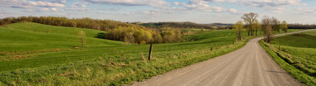
Ah, sweet GPS. Just because I can, I will tell you that this photograph was taken at 39°15’27” N, 81°48’55” W. Put that in your pipe and smoke it. This photo was taken from the side of a road that more or less parallels the Hocking River, a few miles north of Coolville. The river was behind me as I took this photograph, looking into a short, shallow hollow. A hollow (sometimes spelled or pronounced “holler”) is a small valley trailing back into hills or mountains, sometimes dry or sometimes bisected by a stream or creek. Appalachia is full of hollows, some relatively accessible, many rather isolated, and often they may be populated—though as they are often not good for farm or pasture, the people living in a hollow may sometimes be rather impoverished. What you see here is typical of many of the hollow households I come across in rural Appalachian Ohio.

Here is another elevated residence—again, along the Hocking River. Many small residences along Ohio’s major rivers are not year-round homes but the equivalent of summer or vacation homes. The Hocking River used to flood regularly, but I believe there has not been a serious flood since 1990.

Though Appalachian Ohio is itself typically quite hilly, there are flat stretches along the Hocking River—flood plains, I presume—where farming can and does take place. Here is an example (again, the river is behind us from this vantage point), looking across a field at a farm house nestled against (and almost swallowed up by) the hills.

Since I had left Coolville, I had been heading homeward, back towards the Northwest, more or less paralleling my outbound route, only slightly to the east. This route took me through the tiniest of hamlets, Amesville, Ohio (population 154, salute!). The 154 residents can enjoy repasts at Kasler’s County Kitchen, shown above.

My GPS acted up here, but I think this old house was also taken in Amesville, or its outskirts.

I was pleased to discover that my chosen route home would take me through one of my favorite villages in Ohio, the village of Glouster, which I have previously photographed. Glouster (population 1,791, salute!) is an old coal mining town in Appalachian Ohio. A century ago it was a much more bustling and booming place than it is now, but it has lost little in character, as the reproductions of famous paintings that adorn many of its building walls shows.

This reverse shot (of the Sam & Ellen’s Wonder Dog sign building) of a beautiful but sadly decaying little building allows us to imagine what Glouster must have been like when this building was new. The building, you’ll note, is for sale, but it would need major work to salvage it, I fear.

After Glouster, I put my camera away—the light was fading rapidly—and headed straight home. But as I approached Columbus—or, more specifically, the outlying village of Baltimore, Ohio, I came across a site I had seen several years before—a propeller driven plane parked outside a VFW. At that time, I did not take any photographs and soon forgot where the plane was located. So even though it was quite dark when I stumbled on it for the second time, I pulled out my camera and snapped several shots with long exposures, relying on the ability of good-quality modern digital cameras to suck every photon of light into the frame. Thus I was finally able to take an image of this plane.
I was surprised to discover that the plane outside of Baltimore was not a World War II two-engine bomber but rather a Navy P2V Neptune. The Neptune was a land-based plane used as a patrol bomber and for anti-submarine warfare. Designed during World War II, production only began in 1946. Its heyday was the 1950s & 60s, but variants and offshoots survived at least into the 1980s. Based on its designation number, this particular plane flew from around 1954-1964. Several crew members who served on this plane were later members of this particular VFW post, which is how I assume they managed to get hold of it.
Finding that plane again was a great way to end a very nice excursion.
